
Wellington
At
- Sunrise:
- Sunset:
Mainly fine, showers developing this evening. Northwesterlies strengthening through the day.
A few showers, then a period of rain in the morning. Fine spells developing in the afternoon, but showers return toward evening. Gales northwesterlies, gusting 100 km/h, easing late afternoon.
For more detailed weather information visit MetService.
Marine Recreational Forecasts - Wellington
Area Description:
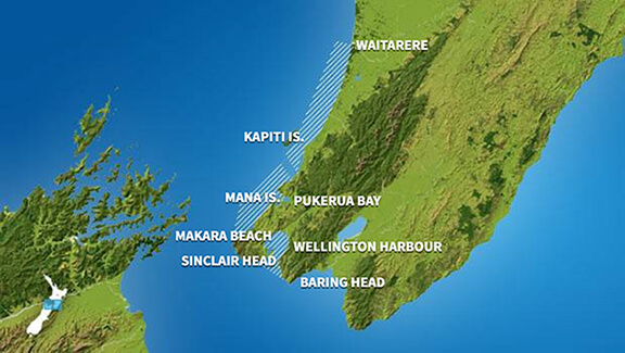
Wellington Harbour and the south coast from Sinclair Head to Baring Head.
Situation:
A low pressure system from the Tasman sea crosses the North Island today. Meanwhile, a broad trough following the low moves onto the South Island and moves south of the Chatham Islands tomorrow as it deepens into a low. On Wednesday, a southwest flow over New Zealand eases as a high over the Tasman Sea extends a ridge over the country. The high moves onto New Zealand during Thursday and lies across central New Zealand on Friday. Meanwhile a front from the south approaches the South Island, and an easterly flow strengthens over the north of the North Island.
Warnings:
Gale warning for COOK
Forecasts:
Strong wind advisory. Monday: Northeast 10 knots. Turning northwest 15 knots this morning, rising to 25 knots gusting 35 knots this afternoon and 30 knots gusting 40 knots this evening. Sea becoming rough this afternoon. Poor visibility in a few morning showers, then fine. For the South Coast and Palliser Bay - Southerly swell half a metre or less. For Castlepoint - Northeast swell 1 metre dying out. Southerly swell 1 metre dying out.
Outlook:
Outlook until midnight Thursday: Tuesday: Northwest 30 knots, changing southerly 20 knots in the afternoon. A few showers. For the South Coast and Palliser Bay - Southerly swell 2 metres developing. For Castlepoint - Southerly swell 2 metres developing. Wednesday: Southerly 15 knots, easing to variable 5 knots early. A few showers. For the South Coast and Palliser Bay - Southerly swell 2 metres easing. For Castlepoint - Southerly swell 2 metres. Thursday: Variable 5 knots, becoming northerly 15 knots early. Fine. For the South Coast and Palliser Bay - Southerly swell 1 metre. For Castlepoint - Southerly swell 2 metres easing.
Swell:
Marine Recreational Forecasts - Mana
Area Description:
Inshore waters from Pukerua Bay to Makara Beach.
Situation:
A low pressure system from the Tasman sea crosses the North Island today. Meanwhile, a broad trough following the low moves onto the South Island and moves south of the Chatham Islands tomorrow as it deepens into a low. On Wednesday, a southwest flow over New Zealand eases as a high over the Tasman Sea extends a ridge over the country. The high moves onto New Zealand during Thursday and lies across central New Zealand on Friday. Meanwhile a front from the south approaches the South Island, and an easterly flow strengthens over the north of the North Island.
Warnings:
Gale warnings for COOK and STEPHENS
Forecasts:
Strong wind advisory. Monday: Northeast 15 knots. Turning northwest 15 knots this morning, rising to 30 knots gusting 40 knots this afternoon. Sea becoming rough this afternoon. Poor visibility in morning showers. Northwest swell half a metre rising to 2.5 metres in the afternoon.
Outlook:
Outlook until midnight Thursday: Tuesday: Northwest 30 knots, changing southerly 15 knots in the afternoon. Showers, clearing. Northwest swell rising to 3 metres for a time. Wednesday: Southeast 15 knots, easing to variable 5 knots early. Becoming easterly 10 knots late. A few showers. Westerly swell easing to 1 metre. Thursday: Easterly 10 knots, turning northerly 10 knots early. Fine. Westerly swell 1 metre dying out.
Swell:
Marine Coastal Forecasts - Castlepoint
Forecast:
*GALE WARNING IN FORCE* Monday : Northwest rising to 20 knots in the morning. Rising to northerly 35 knots but westerly 30 knots north of Honeycomb Rock in the evening. Sea becoming very rough in the south. Long period southwest swell 1 metre, easing. Northeast swell 1 metre. Fair visibility in showers.
Outlook:
Outlook following 3 days: Tuesday: Northwest 35 knots but 25 knots north of Honeycomb Rock, rising to 35 knots everywhere in the morning, turning southwest 30 knots in the afternoon. Sea becoming very rough for a time. Moderate southwest swell developing. Wednesday: Southwest 25 knots, easing to 15 knots early. Rough sea easing. Moderate southerly swell. Thursday: Southwest 15 knots, changing northerly 10 knots early. Moderate southerly swell.
Marine Coastal Forecasts - Cook
Forecast:
*GALE WARNING IN FORCE* Monday : Northerly 15 knots rising to 25 knots in the morning. Rising to northwest 35 knots in the evening. Sea becoming very rough. Poor visibility in morning showers, possibly heavy.
Outlook:
Outlook following 3 days: Tuesday: Northwest 40 knots, becoming southerly 15 knots but 25 knots south of Cape Terawhiti in the afternoon. Very rough sea easing. Moderate southerly swell developing. Wednesday: Southeast 15 knots but southerly 25 knots south of Cape Terawhiti. Sea rough in the south. Moderate southerly swell easing. Thursday: Becoming northerly 10 knots everywhere early. Rough sea in the south easing.