
Christchurch
At
- Sunrise:
- Sunset:
Fine, but cloud increasing this evening. Light winds, but northwesterlies from afternoon.
Showers for a time late morning and early afternoon, with possible thunderstorms and hail about Banks Peninsula, otherwise mainly fine. Northerlies, changing cold southwesterly late morning, with gales gusting 100 km/h in exposed places, easing late afternoon.
For more detailed weather information visit MetService.
Marine Recreational Forecasts - Christchurch
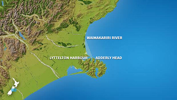
Area Description:
Inshore waters from Lyttelton Harbour to the Waimakariri River mouth.
Situation:
A low pressure system from the Tasman sea crosses the North Island today. Meanwhile, a broad trough following the low moves onto the South Island and moves south of the Chatham Islands tomorrow as it deepens into a low. On Wednesday, a southwest flow over New Zealand eases as a high over the Tasman Sea extends a ridge over the country. The high moves onto New Zealand during Thursday and lies across central New Zealand on Friday. Meanwhile a front from the south approaches the South Island, and an easterly flow strengthens over the north of the North Island.
Warnings:
Nil for CONWAY
Forecasts:
Monday: Variable 5 knots. Northwest 15 knots developing this afternoon, turning northerly 15 knots this evening. Sea slight. Fine. Northeast swell half a metre or less.
Outlook:
Outlook until midnight Thursday: Tuesday: Northerly 15 knots, becoming southwest 25 knots in the morning, easing to 15 knots in the evening. Showers developing. Wednesday: Southwest 15 knots, turning northwest 10 knots early. Easing to variable 5 knots later. Partly cloudy. Thursday: Variable 5 knots, becoming northeast 10 knots later. Fine.
Swell:
Marine Coastal Forecasts - Rangitata
Forecast:
Monday : Variable 10 knots. Northerly 25 knots developing in the afternoon, changing southwest 20 knots late evening. Sea becoming rough for a time. Long period southwest swell 1 metre, easing. Northeast swell 1 metre.
Outlook:
Outlook following 3 days: Tuesday: Southwest 15 knots rising to 35 knots in the morning, easing to 25 knots in the evening. Sea becoming very rough for a time. Moderate southwest swell developing. Wednesday: Southwest 25 knots, easing to westerly 10 knots later. Rough sea easing. Moderate southerly swell. Thursday: Northwest 10 knots. Moderate southerly swell easing.
Marine Coastal Forecasts - Chatham Islands
Forecast:
Monday : Northeast 15 knots, turning northwest 15 knots in the evening. Sea slight. Long period southwest swell 2 metres, easing. Northerly swell 1 metre, easing. Poor visibility in showers from afternoon.
Outlook:
Outlook following 3 days: Tuesday: Northwest 15 knots, rising to 30 knots in the morning, then to westerly 40 knots in the evening. Sea becoming very rough. Westerly swell becoming heavy. Wednesday: Westerly 40 knots, easing to southwest 25 knots early. Very rough sea easing. Heavy southwest swell. Thursday: Southwest 25 knots. Sea rough. Heavy southwest swell easing.
Marine Coastal Forecasts - Conway
Forecast:
Monday : Northeast 15 knots easing to variable 10 knots in the morning. Northerly 20 knots but 30 knots north of Kaikoura Peninsula developing in the evening. Sea becoming rough in the north. Long period southwest swell 1 metre, easing. Northeast swell 1 metre. Fair visibility in a few early morning showers.
Outlook:
Outlook following 3 days: Tuesday: Northerly 20 knots but 30 knots north of Kaikoura Peninsula. Becoming southwest 35 knots everywhere in the morning, easing to 25 knots in the evening. Sea becoming very rough for a time. Moderate southwest swell developing. Wednesday: Southwest 25 knots, easing to 15 knots early. Turning northwest 10 knots late. Rough sea easing. Moderate southerly swell. Thursday: Northerly 10 knots. Moderate southerly swell easing.